River Aire - Cononley
Brief description of fishery:
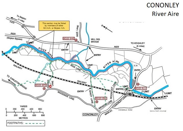
This is mainly coarse fishery of 5.5 km slow-moving water, with fishing on both banks of the River Aire. However, there is a short length of faster water on the right bank downstream of Cononley Bridge, which is more suitable for fly-fishing.
After fishing please complete on-line Catch Returns for this water, it’s easy and helps with fishery development. Catch return input can also be done via the members section.
Location:
Online Google Maps link: BCAA Bradley Ings (Cononley) fishery
Nearest Postcodes:
Left bank fishery: BD20 9HF (Rock Royd Farm) (adjacent to pedestrian access from Keighley Road to the left bank fishery)
Right bank fishery:
BD20 8NU (Shady Lane) (footpath access to the right bank fishery).
BD20 8LU (Cononley Village) (Footpath access to the downstream limit of the right bank fishery)
BD20 8JR (Crosshills Road, Cononley) (Footpath access across the railway line)
Parking:
No parking past the Limit in Shady Lane. This is a narrow lane, liable to be used by farm vehicles, and must be kept clear at all times.
Access:
Right Bank (looking downstream): There are two lengths – the main length upstream of Cononley Bridge and another short length downstream of the bridge. See map for details.
Access to the fishing upstream of Cononley Bridge is on foot only, via Shady Lane or one of the other public footpaths in the area marked on the map. There is no access from Woodside Lane down Swires Lane, except via the public footpath past Throstle Nest. See the map for full access details.
Access to the fishing downstream of Cononley Bridge is via the public footpath from the bridge down the side of the Water Treatment facility, or the footpath from Crosshills Road over the railway foot crossing.
Left Bank (looking downstream): The top limit is at OS map reference SD 990 491, at the end of the second field downstream of where the railway line crosses the river. The bottom limit is at OS map reference SD 993 477, one field downstream of where the beck enters the river.
Access is via the track near Mill Ing Bridge on the A629 (at OS map reference SD 997 479 – limited parking), or via the footpath upstream from Cononley Bridge.
Maps
Species:
- Brown Trout
- Chub
- Grayling
- Pike